Maps
Some of my favourite custom Maps and Atlases I have created using PhotoShop over the years.
(2022)
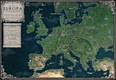
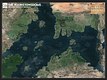
After reading through a lot of Michael Moorcock's fantasy novels last year, I embarked on a creative voyage, composing and remastering maps from his works. Moorcock's 1981 novel of Von Bek (The Warhound and the World's Pain) however combines fantasy with our own history. The novel is set in 1631, and we see Graf Ulrich Von Bek as a Imperial commander during the Thirty Years' War, engaging in the brutal Sack of Magdeburg. Afterwards, he is forced to abandon his company, and eventually meets Lucifer himself - who tasks him with the quest of finding the Holy Grail.
The atlas was finished in late October 2022, and was composed using PhotoShop 2020. I have tried to make it as historically accurate as possible for the time, however Europe was certainly a lot more complicated back in the 1600s! I have also added the fictitious Principality of Wäldenstein also (which was created by Moorcock in a later Von Bek novel). The finished atlas is the product of countless enjoyable hours of reading and writing, I hope you all appreciate it the finished result!

(2022)
After reading through majority of Michael Moorcock's Elric Saga and the Swords Trilogy and creating Maps for both of those worlds, I again felt the desire to map out another of Moorcock's fantasy worlds - this time I decided to go a bit more ambitious, and focussed on the interconnected Six Realms of the Wheel. The Realms feature in the 1986 novel 'The Dragon in the Sword'. The novel is centred around the warrior-Prince Flamadin of Valadeka; a manifestation of Moorcock's many 'Eternal Champions' to feature in the vast majority of his bibliography. Flamadin is first summoned to the Realm of Maaschanheem, and later goes on to aid the denizens of the Six Realms defend against the forces of Chaos that threaten their existence. During his journey; Flamadin travels great distances across many Worlds and travels between them through interdimensional gateways. Whilst reading the novel, I have taken notes on locations visited, mentioned, and associated within this realm for this project.
Geographically, the landscaping and places mentioned are briefly covered, with each of the Six Realms given short geographical overviews though not a huge amount more to go on. I felt more than happy to use my own creative licensing, and employ my knowledge of landscaping and geography to fill in the blanks! Instead of doing a separate map for each Realm, I decided to merge them together into an appropriately designed Wheel layout, with each Realm separated by glowing interdimensional walls. I finished this original Atlas in early October 2022, and created it using PhotoShop 2020.
I hope you enjoy the map! Please feel free to comment and share!
(2022)
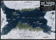
After reading through majority of Michael Moorcock's Elric Saga and the Swords Trilogy and creating Maps for both of those worlds, I again felt the desire to map out another of Moorcock's fantasy worlds - this time focussing on the slowly decaying Frozen World. The World features in the 1970 novel 'Phoenix in Obsidian' (also called 'The Silver Warriors'). The novel is centred around the warrior-Count Urlik Skarsol; a manifestation of Moorcock's many 'Eternal Champions' to feature in the vast majority of his bibliography. Urlik is summoned to this World to aid the last remaining Human settlements defend against the alien race of Moonite Silver Warriors. During his journey; Urlik travels great distances across the World, and whilst reading the novel, I have taken notes on locations visited, mentioned, and associated within this realm for this project.
It is hinted in the novel that this World is also the same setting for one of Moorcock's other novellas; 'The Time Dweller' (1964) (though the events of this novel happened millennia before). In that novel, the planet is simply referred to as "The Chronarch's World", and is inhabited by the mysterious "Scar-Faced Brooder" (another depiction of the Eternal Champion).
Geographically, the World is in its twilight years, and rapidly freezing over on account of its dying sun. The novel depicts a region of unfrozen Earth which contains a great ocean and a number of shorelines that line it, along with large glacial plains that surround the ocean. Though not a huge amount to go on, I felt more than happy to use my own creative licensing, and employ my knowledge of landscaping and geography to fill in the blanks!
I finished this original Atlas in early October 2022, and created it using PhotoShop 2020.
I hope you enjoy the map! Please feel free to comment and share!

(2022)
After reading through majority of Michael Moorcock's Elric Saga and the Swords Trilogy (featuring Prince Corum of the Scarlet Robe) and creating Maps for both of those worlds, I again felt the desire to map out another of Moorcock's fantasy worlds - this time focussing on the ancient World of the Eldren. The World features in the 1957 (updated in 1962, and finalised in 1970) novel 'The Eternal Champion'. The novel is centred around the titular Champion known as Erekosë; a protagonist who is perhaps the first incarnation of Moorcock's many 'Eternal Champions' to feature in the vast majority of his bibliography. Erekosë is summoned to this World by King Rigenos to aid the Human Kingdoms in their conquests against the native Eldren race. During his journey; Erekosë travels great distances across the World, and whilst reading the novel, I have taken notes on locations visited, mentioned, and associated within this realm for this project.
Geographically, there is little to go off for Erekosë's world. Mernadin is described as being a wild yet beautiful frontier, with lush forests, grand mountains and blue lakes, and Zavara is a continent of vast wheatlands, and this is about the extent that Moorcock described the geography of the land! Nevertheless, I felt more than happy to use my own creative licensing, and employ my knowledge of landscaping and geography to fill in the blanks!
I finished this Atlas in late September 2022, and created it using PhotoShop 2020. My own version is adapted from an existing rendition of The World of the Eldren created some fifteen years ago by 'Max von Bek' (from the Moorcock Miscellany Forum Site - link at the bottom of this text box).
I hope you enjoy the map! Please feel free to comment and share!
('Max von Bek's Map: www.michaelmoorcock.net/forum/…)
(2022)
After reading through majority of Michael Moorcock's Elric Saga and creating a Map of the world featured in those stories back in February (The World of the Young Kingdoms), I recently felt the desire to map out another of Moorcock's fantasy worlds - this time focussing on the disc-shaped world of the Vadhagh Prince in the Scarlet Robe; Corum Jhaelen Irsei. Corum is the sorcerer-warrior protagonist of the 1971 'Swords Trilogy' novels; which consist of The Knight of the Swords, The Queen of the Swords, and the King of the Swords.
Geographically, Corum's World features many Celtic themes, Corum's own land of Bro-an-Vadhagh is heavily influenced by Cornish landscaping and mythology, and the land to the west; Lywm-an-Esh is likely based off of the mythical land of Lyonesse (from Arthurian Legend). I finished this Atlas in September 2022, and created it using PhotoShop 2020. My own version is adapted from an existing rendition of Corum's World created some fifteen years ago by 'Max von Bek' - aided by 'Governor of Rowe Island' - both from the Moorcock Miscellany Forum Site (link at the bottom of this text box).
I hope you enjoy the map! Please feel free to comment and share!
('Max von Bek's Map: www.michaelmoorcock.net/forum/…)
(1998 - 2000)
Ever since I first had the pleasure of being read Michael Moorcock's epic 1965 novel; Stormbringer! (as a kid of around 10 years old at the time), I have held an undiminishing love of Moorcock's works. Back then, it was the first time I was exposed to Fantasy literature and the experience opened up an exciting world of endless possibility! I was fascinated by Stormbringer!'s multi-faceted antihero; the Eternal Champion, Elric VIII; Emperor of Melnibone, and have thoroughly enjoyed reading about his many quests and experiences ever since my initial introduction.
(2022)
In late 2021 I decided to read through the vast majority of the Elric Saga, and I documented all mentions of geography within the world of Elric. I focused primarily on the western continent - where Melnibone and The Young Kingdoms are situated. Once I had finished my research, I wrote my findings into a sort of geographical compendium, and it came to around fifty pages of research by the time I had finished reading the final book in the saga; Stormbringer!. From the research, I felt confident that I could make a realistic and true-to-Moorcock atlas of the Young Kingdoms, finishing the atlas in February 2022. The Atlas was created using PhotoShop 2020, and is the product of countless enjoyable hours of reading and writing. I have loved every second of my Elric odyssey, and I hope you all appreciate the fruit of my labor of love.
(2010 - 2013) (on and off)
Project Solum was a personal project between me and several of my friends, where we built a fantasy world, established unique civilizations of our own, and pitted them against each other in the name of global conquest - in a sort of self-made tabletop equivalent of Medieval: Total War. The Project Solum maps were part of a steampunk/fantasy/industrial revolutionary setting, in a world populated by warring Empires vying for technological and military dominance of the world.
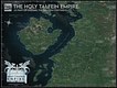
(2019)
This map was made using PhotoShop CS5 adapted and updated from three previous versions (also made in CS5). I created this 6 years after we had ceased the original Project, as I had had an urge to hone my cartographical skills and also expand the lore and realism of my own favorite created nation; The Holy Talfein Empire. I have included a few paragraphs below from my old writings on the Holy Talfein Empire providing an overview of the nation and its people.)
THE HOLY TALFEIN EMPIRE
"The Empire once spanned the entire central continent of Ardora during the Great Requisition in 1119 RTE. The Talfein had set up a crusade and a continental scale incursion proceeded. There were many battles and conflicts during this foray, but overall the Talfein had claimed Ardora a lot quicker and with fewer casualties as had been estimated - This was said to be because of the religious influence throughout the continent, many people from other nations didn’t just see the Talfein as violent crusaders, but as a salvation to their hardships, the High Order could provide a stable and prosperous governing rule, and present well-paid jobs to the local people, who before had just been struggling to survive. The religious benefits and promises also served to be a massive factor in controlling the other nations. The people were encouraged to live a sin-free lifestyle with the promise of utopian afterlife. There were of course, many that defied the Crusaders. The Talfein faced heavy resistance from more powerful and educated citizens in the larger cities. But at the time, they were no match for the Empire, who tactfully and covertly killed off all of the most influential protestors whilst increasing the prominence of the religious teachings. It wasn’t long before people were either converted or too afraid to resist. In any case, the Talfein had gained control over the land and had united the nations under one rule; the rule of the High Order. The actual word ‘Talfein’ means ‘blessed children’ in the old language spoken in the ancient Tomes. For over a hundred years, the land had become a peaceful and united entity under the will of Ardor and his Talfein enforcers. It was a dream however that would not last, and something was brewing within its newly established empire.
In 1244 RTE, Supreme Fein Falcar Moziak was assassinated while he attended the annual parade at the city of Proxis. This event sparked widespread shock and uncertainty and marked out the beginning of the revolution. The sheer scale and spread of the mutiny made cracks in the empire. The royal family and the Order were sent into a state of disarray and the people lost faith in its ruling body and in Ardor. Bands of heretic rebels started to appear and soon turned into large impetuous armies baying for revolution. The surrounding nations took up arms and defeated the nearby Talfein colonial forts and amassed a continental scale assault on the Talfein Capital realm on the Middle Western shoreline and on the isle of Augury itself. The Empire was prepared however and managed to assemble a grand army to protect the Talfein homeland. Waves of heretic militia crashed against the shields of zealous Talfein elites. The rebels managed to gain control of their former territories but could not take over the more compact parts of the Order territory. After four years of conflict, the invading rebels sent an emissary to meet with the High Order on the Isle of Ardor with an agreement in mind. The emissary proposed a truce between the two opposing forces in which the Isle of Augury and other preliminary Talfein territory may remain untouched and that the surrounding exclave territories are reverted back to their former state (prior to the Talfein Great Requisition in 1119 RTE) The High Order accepted the offer in 1249, thus ending the war. With the ‘Malaga Pact’ in full effect, the Order withdrew their soldiers from the other surrounding realms and they returned to the motherland on the Middle Western shoreline. The Talfein Empire managed to keep a large percentage of their original land but they had lost a lot of their influence and trust within the other surrounding nations.
Through the course of a decade, the High Order set about rebuilding its once powerful and influential empire. The Talfein towns and cities that had suffered during the uprising were being restored and its demoralized citizens needed guidance from Ardor. With the previous Fein Moziak dead, a new Fein needed to be crowned. The title went to a pure-blood Talfein military commander, whose brilliant leadership and wisdom guided the Talfein People through the hard reconstruction process. He was one of the youngest to ever rule in the history of the Empire at the time (aged 26) Valdaemar Favonius was a regal and esoteric man, a fierce believer in Ardor’s teachings. He had been a commander in the war, and had been posted in the city of Barbassy. The city had been hit hard by the rebels, but with Favonius’ excellent tactics and leadership, the city prevailed and was kept under Talfein control. It was an impressive feat, considering other cities in similar scenarios had fallen. Favonius had an inexplicable aura about him, he was calm, highly regarded and a skilled tactician and warrior, yet behind his white eyes lay intense anger and pain. The High Order knew of his reputation and praised him for his excellent leadership during the war. The people were most impressed because of Favonius’ angelic white hair and bright ashen eyes, uncommon features highly regarded and desired within the Talfein population. Supreme Fein Favonius took his newly appointed role with honor and zeal, he set about making changes within Talfein society, he increased taxation and put a lot of funding towards the empire’s military and weapons technology as well as restoration. By 1264 RTE the Talfein Empire had been restored to its original glory and power prior to the Great Requisition. By this time, the surrounding territories had also regained control and restored/appointed ruling governments or monarchies."
(Please don't hesitate to check out my other works! Many thanks for looking/reading!)
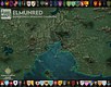
(2020)
Elmunred was a regional map I crafted as a visual aid of a Dungeons & Dragons (Pathfinder) Campaign I hosted (which intermittently from 2014 - 2016). The campaign was very much Game of Thrones inspired, and featured it's own civil conflict as well as powerful, established families - 'Houses'. To accompany my campaign and map, I wrote a huge compendium detailing the history, lore, people, conflicts, and technologies of the Elmunred inhabitants. As we played through the campaign, I started and updated a blog detailing the events transpired as my campaign progressed. (If you're interested, I've put a link to it here: alexcampaign.blogspot.co.uk/. I hope you enjoy!)
(Please don't hesitate to check out my other works! Many thanks for looking/reading!)

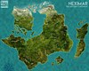
(2015)
Elimeria was a regional map I crafted as a visual aid of a Dungeons & Dragons (Pathfinder) Campaign an old friend of mine hosted.
(Please don't hesitate to check out my other works! Many thanks for looking/reading!)

(2010 - 2013) (on and off)
Project Solum was a personal project between me and several of my friends, where we built a fantasy world, established unique civilizations of our own, and pitted them against each other in the name of global conquest - in a sort of self-made tabletop equivalent of Medieval: Total War. The Project Solum maps were part of a steampunk/fantasy/industrial revolutionary setting, in a world populated by warring Empires vying for technological and military dominance of the world.
(2018)
This particular map was created in PhotoShop CS5 adapted and updated from two previous versions (from 2010, and 2011 respectively - also made in CS5). I created this 5 years after we had ceased the original Project, as I had had an urge to hone my cartographical skills and also give the map a newer updated feel. I have included a few paragraphs below from my own writings on Cantari providing an overview of the continent and its peoples.)
CANTARI
"Situated near the equatorial line of Solum, the continent of Cantari is a fertile, temperate land, painted with dense forested regions, open plains and extensive mountain formations. The continent is split into two major landmasses. The easternmost is Ardora, which is the largest, most populous of the two, and the westernmost is Loridia, also called the ‘sister’ isle. Geographically, Ardora hosts the largest forest on Cantari; the Banbaryx (situated in the wildlands of Byrnae), as well as the highest peak; Mount Vask (in the northerly Muldan Mountain range). Frozen steppes and taiga are also present on the far-northern expanse of the land. Across the channel, Loridia hosts exquisite crystal-peaked mountain ranges in the far north (the Suu’nartha Range), and a searing desolate region to the extreme south; known as the Great Desert of Khal Dún. The central territories on the continent possess the most fertile soil, and there are countless acres of flowering plants as well as more humble crops, and other edible flora. There are a variety of smaller landmasses and islands dotted in and around Ardora and Loridia. In the center sits Augury; a land of unfathomable allure, on the northernmost coastline is a scattering of islands, and to the extreme south sits Natai; a dark and jagged rockland largely devoid of life. On the eastern fringe of the continent sits Tocha; a thin stretch of land, littered with deep jungles and crowned with a large active volcano; Mount Ygasta.
Of all the realms on Solum, Cantari boasts perhaps the most diverse range of civilizations. The extreme geography and climate ensured a rich and exotic patchwork of cultures and races. By many, even to this day, Cantari was revered as a paradise. The abundance of natural resources combined with its arable land, and agreeable climate also attracted people from outside of the continent, and as such, the patchwork of civilizations became even more elaborate. To name a few different races on Cantari; there are the Classical (also called Virtuan) people, thought to be descendants of the original inhabitants of Cantari. They are a humble, fair skinned, and medium haired people, commonplace throughout the continent. Many of the denizens of the great desert realm on Loridia as well as a percentage of Ardoran people on the south shore have a dark complexion on account of the extreme heat of the region. Generations of exposure to the sun have altered the pigment in their skin. They are a hard fairing, versatile people. In the northern reaches of the continent sit the pale-skinned, light-haired Núrian people, they are a sea-faring people, and many of them are attuned fighters. In the central Isle of Augury lives a blue-skinned, fair-haired race of people with pointed ears. These Augurians possess physical characteristics vastly different to those of other races on Cantari (and indeed Solum as a whole). They are an isolationist people, deeply religious, yet ambitious beyond measure. In the current age, Cantari is celebrated as a cosmopolitan utopia, although this is not to say that there haven’t been culturally motivated conflicts in the past. On the contrary, Cantari has endured some of the longest wars and the fiercest battles on the planet, and many attribute this fact to the extreme diversity of is people.
There is at least three thousand years of recorded history for the Cantarian peoples, the majority of which earliest records appear after the inception of Virtuanity; which is a social ideology that underlined and officialized the first common laws, and built the foundations of today’s governments. Virtuanity is still recognized in the current age, and practiced by the vast majority of Cantarians. Since that time, the denizens of Cantari established themselves as nations, developing and growing through trade, diplomacy, and conquest. There have been many cultural and technological revelations throughout the ages. Great temples, political buildings, memorials, and castles are dotted throughout the land, and there are cities that span several miles, and can hold over a million people. The invention of the steam-powered train marked the beginning of an era known as the Solum Renaissance (ASR), a time-period recognized all over the world as being the dawn for technological development. Since then, many spectacular and life-altering creations have arisen – there are inventions that serve as a boon to humanity, however there are also inventions that are destructive in nature and purpose. Even now in the current age, there are new technological advances being tested and implemented in day-to-day life. It is fair to say that these are uncertain times for the denizens of Cantari, on one hand, the changes are beneficial and exciting and then on the other hand, there is the potential for widespread fear and devastation. As it stands, the year is 1863 ASR, and there are some three hundred million souls living on Cantari, spread across eleven sovereign states, and everywhere in-between.
(Please don't hesitate to check out my other works! Many thanks for looking/reading!)
(2010 - 2013) (on and off)
Project Solum was a personal project between me and several of my friends, where we built a fantasy world, established unique civilizations of our own, and pitted them against each other in the name of global conquest - in a sort of self-made tabletop equivalent of Medieval: Total War. The Project Solum maps were part of a steampunk/fantasy/industrial revolutionary setting, in a world populated by warring Empires vying for technological and military dominance of the world.
(2011)
This particular map was created in PhotoShop CS5 adapted and updated from one previous version (from 2010) (also made in CS5).
(Please don't hesitate to check out my other works! Many thanks for looking/reading!)
(2022)
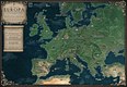
After reading through a lot of Michael Moorcock's fantasy novels last year, I embarked on a creative voyage, composing and remastering maps from his works. Moorcock's 1986 novel of Von Bek (The City in the Autumn Stars) however combines fantasy with our own history. The novel is set in 1793-1794, and features the ancestor of the first novel's protagonist. Ritter (knight) Manfred Von Bek is a sort of philosophical soldier-of-fortune who travels hither and yon in search of passion and meaning, eventually he meets a string of eclectic and supernatural people, and travels to the otherworldly City in the Autumn Stars - where he meets a certain fallen angel and is sent on a quest of finding the Holy Grail.
The atlas was finished in late November 2022, and was composed using PhotoShop 2020. I have tried to make it as historically accurate as possible for the time, however Europe was certainly a lot more complicated back in the 1700s! Note also the fictitious Principality of Wäldenstein (which was created by Moorcock for this novel.). The finished atlas is the product of countless enjoyable hours of reading and writing, I hope you all appreciate it the finished result!